



Hiking & nature · Near Lajares
Calderón Hondo
A circular trail from Lajares crosses volcanic terrain to the crater rim. Find the trailhead, official route and practical tips for your hike.
Calderón Hondo at a glance
- Trailhead
- Lajares, northern Fuerteventura
- Walking time
- About 90 minutes on the official loop
- Distance
- About 5 km on the loop
- Difficulty
- Easy, with rocky sections
Fuerteventura’s volcanic landscape
A crater with views to the Atlantic
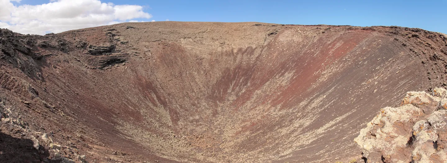
Calderón Hondo is one of a chain of volcanic cones between Lajares and Corralejo. Its near-circular crater is particularly well preserved.
From the viewpoint you can see layers of ochre, red and dark volcanic rock on the steep inner walls. The crater is about 70 metres deep.
The rim gives you a clear view into the crater, with the dark lava fields and low hills of northern Fuerteventura beyond it.
In clear weather you can look out to the Atlantic, the island of Lobos and Lanzarote.

Inside the crater · Norbert Nagel · FreshSurf
Calderón Hondo is one of the easiest volcanic craters to visit in northern Fuerteventura. A stone-paved trail near Lajares crosses open lava fields to a viewpoint on the rim, where you can look down into the crater.
The route takes you past dark volcanic rock and reddish hills. On clear days the view extends across the coast to Lobos and Lanzarote. Plan a half-day for the walk and a stop in Lajares.
You need a steady footing on uneven ground. Check the wind before heading out, as the final stretch and viewpoint are exposed.
Plan your hike
Hiking Calderón Hondo from Lajares

Trail to Calderón Hondo · Alexey Komarov · FreshSurf
Start at the northern edge of Lajares and follow the signed SL-FV-2 through open volcanic terrain to the viewpoint.
-
1. Start at the edge of Lajares
Leave the last houses behind and follow the stony track. This first stretch is gradual, with more of the surrounding landscape coming into view as you climb.
-
2. Follow the trail uphill
The path steepens as you approach Calderón Hondo. Watch your footing where the surface changes from paving to loose volcanic stones.
The ascent is short, but heat, wind and a lack of shade can make it feel harder than the distance suggests.
-
3. Pause at the crater viewpoint
Take your time at the signed viewpoint to look down into the crater and across the lava fields. From the exposed rim you can feel the wind even when it was calm in Lajares.
On a clear day, the outline of Lobos and the hills of Lanzarote are visible across the water.
-
4. Return to Lajares
Follow the signed SL-FV-2 loop back to the trailhead. If you have planned an out-and-back walk, retrace the same marked path.
Keep village walking time separate from the official route distance, especially if you plan to catch a bus afterwards.
Getting to Lajares
Getting to the Calderón Hondo trailhead
Calderón Hondo lies north of Lajares and is easy to reach from Corralejo, El Cotillo and La Oliva.
By car, head to Lajares, then follow the road towards Majanicho to the signed trail access. Use the official map to check the trailhead before you set out.
Parking near the usual access points is limited. Use only suitable spaces and keep access roads and tracks clear.
Without a car, check the buses to Lajares and allow time for the walk from the stop. Our Lajares village guide helps you get your bearings.
Before you set out
Best time to hike Calderón Hondo
You can hike throughout the year. In this exposed terrain, the temperature, the sun and the wind are more useful guides than the calendar.
Go early or later in the afternoon for cooler temperatures. In summer the sun can be intense, and exposed ridges can be windy even in the cooler months.
If strong wind, rain or poor visibility makes the rim uncomfortable or the surface uncertain, turn back early. Leave enough daylight to return.
What to bring on the volcano hike
- Sturdy shoes with grippy soles
- Enough drinking water
- Sunscreen, sunglasses and a hat
- A light windproof layer
- A charged phone with an offline map
- A snack
Carry all the water and food you will need. There are no reliable facilities on the trail.
Stay on the existing paths, take your rubbish back with you and leave the rocks and wildlife undisturbed.
Hiking with children
The signed route suits walkers with basic fitness who are comfortable on an uneven surface. There is no technical climbing on the usual route.
Children who already enjoy walking can come along if the distance and weather suit them. Keep them close at the exposed viewpoint and give yourself time for breaks.
The stony ascent is unsuitable for pushchairs and can be difficult for visitors with limited mobility.

Calderón Hondo access path · Jarek Prokop · FreshSurf

View over northern Fuerteventura · Alexey Komarov · FreshSurf
Frequently asked questions about Calderón Hondo
How long does the Calderón Hondo hike take?
Allow about 90 minutes for the official SL-FV-2 loop and around 1.5 to 2 hours for an outing from the edge of Lajares with stops. Add time if you start in the village centre.
How high is Calderón Hondo?
Calderón Hondo rises to about 278 metres above sea level. Its crater is around 70 metres deep.
Is there an entry fee for Calderón Hondo?
The usual walking route is free and generally does not require a reservation.
Can you walk down into the crater?
The designated trail leads to the viewpoint at the crater rim. Stay on the marked paths and keep away from the steep, loose slopes.
Do you need a guide to hike Calderón Hondo?
You can follow the usual walking trails independently. A guide can add context if you are interested in Fuerteventura’s volcanic history.
Are there toilets or refreshments at the volcano?
Plan as if there were no toilets, drinking-water points or refreshments on the trail. There are cafés and shops in Lajares.
Explore more of northern Fuerteventura
Lajares
Once you are back in Lajares, take a break in the village before the next stop. There are small shops and cafés for coffee, juice or lunch.
Barranco de los Enamorados
Walk between pale sandstone walls on another day trip near El Cotillo.
From Lajares you can head to the coast near El Cotillo or the beaches around Corralejo. A morning on the volcano and an afternoon by the Atlantic fit easily into the same day.
See a different side of Fuerteventura
There is more to Fuerteventura than days by the sea. Calderón Hondo makes it easy to see the island’s volcanic landscape on a short walk, and you can be back by the ocean later the same day.
Find more routes in our Fuerteventura day trips guide.
Sources and photo credits
FreshSurf editorial team in El Cotillo · Route checked against official visitor information.
- Visit Fuerteventura · Calderón Hondo
- Fuerteventura Turismo · SL-FV-2
- Travel Fuerteventura · Calderón Hondo volcano
- Travel Fuerteventura · Lajares–Corralejo volcano hike
- Crater panorama · Tamara Kulikova · CC BY-SA 4.0 · resized and converted to WebP
- Crater interior · Norbert Nagel · CC BY-SA 3.0 · resized and converted to WebP
- Trail · Alexey Komarov · CC BY-SA 4.0 · resized and converted to WebP
- Access path · Jarek Prokop · CC BY 3.0 · resized and converted to WebP
- Viewpoint · Alexey Komarov · CC BY-SA 4.0 · resized and converted to WebP